
Northern and Western Geelong Growth Areas Precinct Structure Plans
The Victorian Planning Authority (VPA) now part of the Department of Transport and Planning is leading the preparation of four Precinct Structure Plans (PSPs) in Geelong’s Northern and Western Growth Areas (NWGGA).
The NWGGA is the largest greenfield planning project in regional Victoria, covering approximately 5,300 hectares. Once complete, it is expected to provide around 40,000 new homes and employment opportunities for a future population of approximately 112,000 people.
To deliver these homes the State will lead four PSPs in addition to the three already commenced by Council. The State-led PSPs include:
- Batesford North
- McCanns Lane / Merrawarp
- Batesford South
- Heales Road East
The VPA will undertake work on these PSPs concurrently where possible. We will also draw on existing work already completed for the NWGGA Framework Plan where it is appropriate. VPA will prioritise Batesford North and McCanns Lane/Merrawarp for completion ahead of Batesford South and Heales Road East. Opening up these areas will create additional housing capacity across different growth fronts, complementing the three Council-led PSPs that have already commenced, these include:
- Creamery Road
- Elcho Road West and Heales Road West (now known as Elcho Road West)
- Elcho Road East
These PSPs will help the City of Greater Geelong meet the housing targets outlined in Plan for Victoria while ensuring growth is supported by the timely managed delivery of transport, community and other essential infrastructure. They will provide a framework for development for the next several decades, creating well-planned and liveable communities for current and future residents.
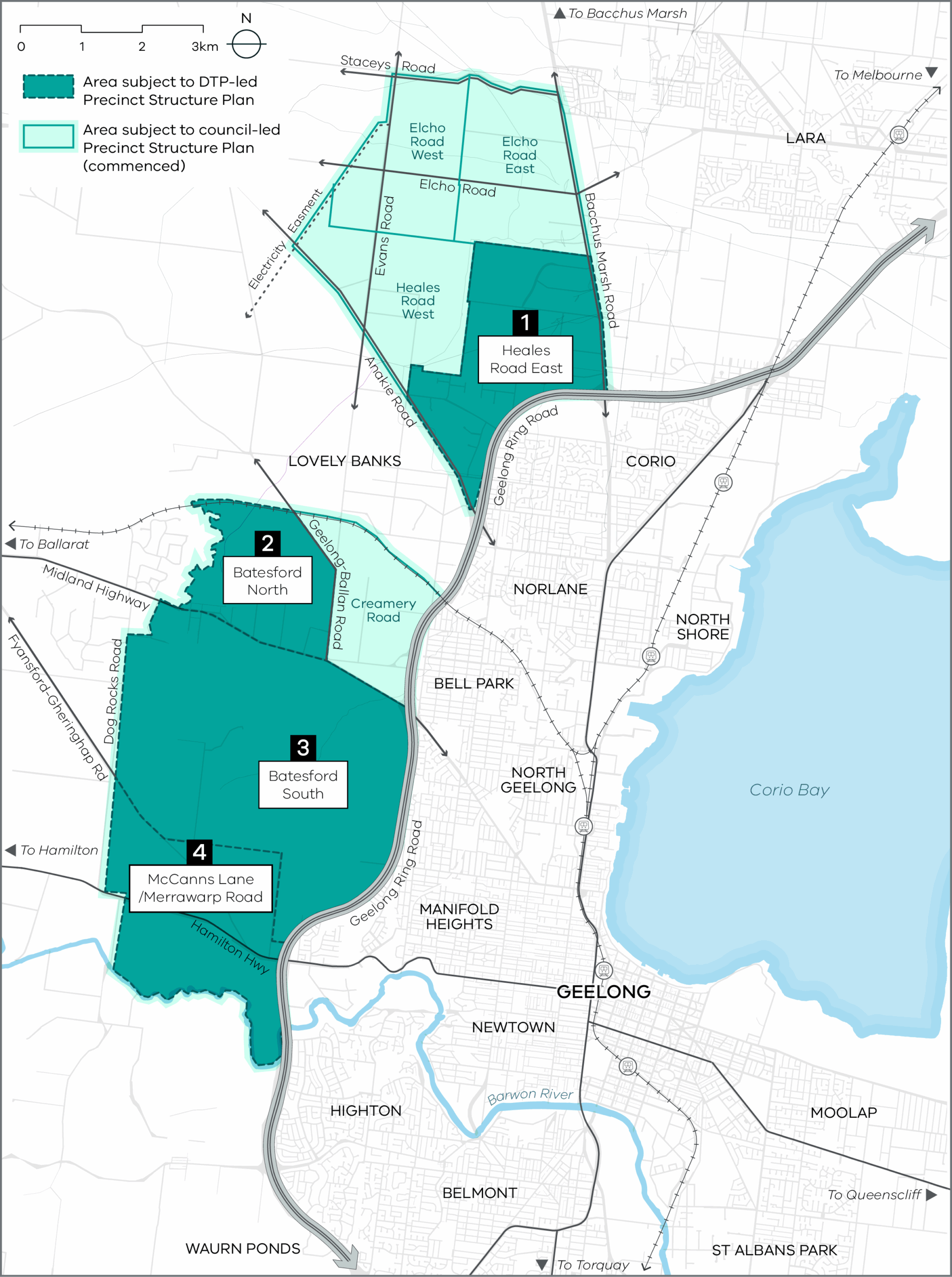
Northern and Western Geelong Growth Areas graphical representative map
About the project
The Northern and Western Geelong Growth Areas were identified in the Northern and Western Geelong Growth Area Framework Plan 2020.
The Northern and Western Geelong Growth Areas are a key part of the Victorian Government’s strategy to address population growth and meet housing and employment demands. The Northern and Western Geelong Growth Area Framework Plan supports this work, setting out a strategic framework for the development of land across two large growth areas in Greater Geelong’s north and west.
With the Northern and Western Geelong Growth Area Framework Plan now in place, precinct structure plans (PSPs) form the next layer of planning. They translate the Framework Plan’s higher-level vision into more detailed, precinct specific plans that guide how land will be developed, including the location of housing, town centres, community facilities, schools, roads, parks, sporting reserves and other enabling infrastructure.
The Victorian Planning Authority (VPA) now part of the Department of Transport and Planning and the City of Greater Geelong are preparing seven precinct structure plans to help unlock 40,000 new homes. These include:
State-led:
- Batesford North
- McCanns Lane / Merrawarp
- Batesford South
- Heales Road East
Council-led:
- Creamery Road
- Elcho Road West and Heales Road West (now known as Elcho Road West)
- Elcho Road East
The Victorian Planning Authority was integrated into the Department of Transport and Planning on 1 January 2025.
Our key priorities include unlocking land for new homes and communities, facilitating housing diversity and affordability, job creation and better development of new communities in growing and established areas.
The VPA will lead the preparation of four of the seven precinct structure plans within the Northern and Western Geelong Growth Areas:
- Batesford North;
- McCanns Lane / Merrawarp Road;
- Batesford South; and
- Heales Road East.
The City of Greater Geelong is a key stakeholder and the VPA will engage closely and regularly with Council throughout the process.
Once the PSPs are approved, Council will become the responsible authority, meaning it will be responsible for assessing and approving planning permit applications in accordance with the approved PSPs.
While VPA is preparing four of the PSPs, Council is concurrently leading preparation of three: Creamery Road, Elcho Road West and Elcho Road East.
VPA are currently reviewing the existing body of work and scoping the project program. Until this process is complete, we are unable to provide definitive timeline advice.
Once this phase is complete, the VPA will update landowners on timing.
Throughout the preparation of these PSPs, the VPA will be engaging with landowners within each precinct, relevant government agencies, and the City of Greater Geelong.
To receive bi-monthly updates, subscribe to the project via the ‘Subscribe Now’ section of this webpage.
Once the PSPs are approved, development within each precinct will occur gradually over the next few decades.
The City of Greater Geelong is the responsible authority for each PSP and will be responsible for the planning application process that will deliver outcomes as outlined in the PSPs and DCPs.
Developers are responsible for preparing and lodging planning applications that must be generally in accordance with outcomes of the PSPs and DCPs.
What is a Precinct Structure Plan?
The Precinct Structure Plan (PSP) is a long-term plan for urban development. It describes how the land is expected to be developed and how and where services and infrastructure are planned to support the development of new communities.
What is a Development Contributions Plan?
A Development Contributions Plan (DCP) establishes a framework for developers to make a financial contribution towards the cost of key infrastructure projects, providing certainty for the future community around infrastructure timing, funding and delivery.
A DCP is based on detailed assessments across transport, community infrastructure, drainage, and utilities, and sets out the infrastructure items required to support the new community.