Arden Structure Plan and Planning Scheme Amendment C407melb to the Melbourne Planning Scheme
The Arden Structure Plan and Planning Scheme Amendment C407 was approved by the Minister for Planning and gazetted on 28 July 2022 under Amendment C407melb to the Melbourne Planning Scheme.
Amendment C407melb to the Melbourne Planning Scheme implements the Arden Structure Plan, July 2022 and Development Contributions Plan, July 2022 by introducing new planning controls into the Melbourne Planning Scheme.
Gazettal of Amendment C407melb is an exciting milestone. It paves the way for the urban renewal of the Arden Precinct to begin developing into a thriving innovation precinct in anticipation of the Metro Tunnel’s Arden Station opening in 2025. It will be a vibrant, mixed use innovation precinct comprising four distinct and diverse neighbourhoods.
To view a copy of the final amendment documentation, including the Arden Precinct Development Contributions Plan, refer to:
- Amendment C407melb
- Arden Precinct – Arden Structure Plan – July 2022 (PDF) (Approved and Gazetted)
- Arden Precinct Development Contributions Plan – July 2022 – Amended December 2023 (VC249) (PDF) (Approved and Gazetted)
- Arden Precinct – Cross Sections – July 2022 (PDF) (Approved and Gazetted)
- Arden Precinct – Arden Precinct Parking Plan – August 2021 (PDF) (Approved and Gazetted)
- Arden Precinct – Arden Precinct Flood Management Policy – June 2022 (PDF) (Approved and Gazetted)
Arden Precinct
Arden will be a new destination for Melbourne, setting the standard for urban renewal.
Located around the Metro Tunnel’s Arden Station, Arden will become an employment and innovation precinct and a thriving new neighbourhood that will accommodate 34,000 jobs and 15,000 residents.
The precinct will transform the area into a distinct and thriving integrated inner-city neighbourhood in Melbourne’s north-west.
The Arden Structure Plan and amendment C407melb supports the delivery of around eight hectares of new green open space. This includes local parks, two community facilities, a proposed primary school and a potential health facility to cater for the community. Planning controls will protect the open spaces from natural impacts like wind and overshadowing from buildings.
Amendment VC249
The Development Contributions Plan (DCP) for this precinct was amended as a result of Amendment VC249.
On 15 January 2024, Amendment VC249 came into effect to further facilitate the development of small second dwellings introduced by Amendment VC253. Amendment VC249 exempts development for a small second dwelling from existing development contributions plans. The changes ensure an applicant does not pay a development contribution when a small second dwelling is developed.
For further information on the amendment and the updated DCP, refer to:
Background information
The Victorian Planning Authority (VPA) is a State Government statutory authority within the Department of Transport and Planning that reports to the Minister for Planning.
The VPA’s main task is to make sure Melbourne and Victoria’s regions remain great places to live and work. This requires vision and long-term planning to ensure our growing population has equitable access to employment, public transport, attractive public spaces and affordable housing.
Our key priorities include unlocking land for new homes and communities, facilitating housing diversity and affordability, job creation and better development of new communities in growing and established areas.
We do this by working closely with councils, government agencies and the planning and development community on integrated land use and infrastructure coordination for new communities and strategically important precincts.
With the completion of the Metro Tunnel and the new Arden Station by 2025, Arden will become a new destination for Melbourne and an employment hub on the doorstep of Melbourne’s central city.
The Metro Tunnel will create a new chapter for Arden by linking the precinct to the Parkville National Employment and Innovation Precinct and the city to the east, Footscray and Sunshine to the west, and Melbourne Airport Rail when it opens in 2029.
The plans for Arden build on the Victorian Government’s investment in infrastructure, creating a platform for sustainability, liveability, investment and innovation.
In the wider context, large urban renewal projects like Arden are vital to retaining Melbourne’s liveability as it grows beyond 8 million people, by providing new homes, jobs, community facilities and open spaces in connected locations.
We want Arden to already be a thriving destination by the time the Metro Tunnel opens. We’re working to finalise the planning controls now so that development of the future precinct can begin before Arden Station opens in 2025.
The VPA and the City of Melbourne prepared the Arden Vision and draft Arden Structure Plan. The VPA prepared the Arden Structure Plan and draft planning scheme amendment in consultation with the City of Melbourne, for public consultation now.
The City of Melbourne is responsible for delivering and maintaining local infrastructure and will be responsible for administering the Development Contributions Plan. The City of Melbourne will also be the responsible authority which means they will be responsible for administering planning applications in Arden under the Melbourne Planning Scheme.
The Minister for Planning will be the Responsible Authority where a development application exceeds a threshold of 25,000 square metres of gross floor area, for which the City of Melbourne would typically provide comments to the Minister.
The City of Melbourne is a partner in this engagement process, supporting the VPA as the lead agency for the amendment.
The Department of Transport (DoT) is responsible for coordinating the planning and delivery of Arden across all of State Government. The VPA is working with DoT to prepare the Arden Structure Plan and draft planning scheme amendment.
Melbourne Water is responsible for delivering and maintaining major critical flood management infrastructure and will be the collecting agency for contributions under the Urban Renewal Cost Recovery Scheme (URCRS).
Melbourne Water is a referral authority in the planning system. Melbourne Water provides advice on building, planning and subdivision applications and if necessary, places conditions on development and subdivision permits for land that is impacted by flooding. This ensures that new developments are designed to protect occupants from flooding, and that Melbourne’s drainage system functions at design capacity.
About the planning process
Our plans for Arden have been shaped by the insights and priorities of the Arden community.
We engaged the community on the Draft Arden Vision & Framework in 2016, the Draft Arden Structure Plan in 2020 and the Arden Structure Plan and Draft Planning Scheme Amendment in 2021
We heard from about 900 community members over the course of these three phases, which helped ensure our vision and plans for the precinct captured the aspirations of Arden’s diverse community.
Find out more about what we’ve heard previously from the Arden community in our community consultation reports:
Your feedback on the Arden Vision told us:
- You support the area becoming a mixed-use precinct, with significant potential as a future knowledge-based jobs hub
- There should be a distinctive identity for Arden which retains North Melbourne’s sense of character
- The precinct should be as environmentally sustainable as possible
- It is important to have connected and diverse open spaces and generous tree-lined streets
- Public transport, walking and cycling are preferred modes of transport, with improved walking and cycling connections being the priority
- It is important to consider local communities and support existing businesses during development
- Affordable housing should support the education, research, and community service sectors
- The precinct will need additional community facilities.
Your feedback on our Draft Arden Structure Plan told us:
- The importance of creating relaxed, informal places where people can gather, relax or exercise
- Reflecting and respecting the heritage of the area will help ensure the precinct develops as a cohesive neighbourhood
- You want to see a sustainable, socially inclusive neighbourhood where high-quality construction and design will create a peaceful place to live
- You want a clear framework for the delivery of environmental sustainability initiatives
- You want the precinct to be safe and connected for cyclists and pedestrians while remaining accessible to all
- You want the car parking approach to consider the needs of the disabled, elderly, people with children and workers who require cars
- You want the buildings to be built to last, the open space to be green and safe, with small, locally owned business to service the needs of residents
- There was overwhelming support that the project must deliver on affordable housing, and that affordable housing targets should be more ambitious
- There is concern about building heights, particularly in relation to overshadowing and wind impacts.
We also heard from Traditional Owners that they generally support our approach to embedding Aboriginal cultural values and heritage, and emphasised the importance of encouraging cultural inclusion and expression.
You can find more detail about the feedback we have received in the below documents:
We’ve made updates to the Arden Structure Plan since we released the Draft Arden Structure Plan for consultation in June 2020. These are based on community feedback, as well as expert technical reports and further analysis and testing.
Key changes include:
- Reduced the precinct boundary to remove land covered by the West Melbourne Structure Plan
- Slight changes to street layouts and cross sections to reduce the need for land acquisition and better reflect existing property boundaries
- Expanded the investigation area for a potential future health institution in Arden Central
- Updated the integrated stormwater management open space in Arden North to change its shape and serve as a sports oval during dry periods
- Updated floor area ratios and building heights, and updated guidelines for managing wind protection and overshadowing
- Refined indicative through-block links to better align with property boundaries
- Refined car parking to better reflect community needs
- The Arden Central sub-precinct has been split into two: Arden Central – Innovation and Arden Central – Mixed Use, each with distinct land use visions and built form controls
You can find a full list of changes to the Arden Structure Plan in the Changes to the Arden Structure Plan document in the Supporting Documentation section of this page.
Understanding planning controls
A Land Subject to Inundation Overlay (LSIO) is a type of planning control that identifies properties that may be affected by flood risk.
An LSIO is designed to prompt the early consideration of flood risks in the planning process and provide guidance and standards on how these sites should respond to that flood risk.
Parts of Arden are subject to flooding and are covered by an LSIO. The City of Melbourne is proposing to amend the area covered by the LSIO in Arden and other areas to reflect updated flood modelling. This is being done through Amendment c384 to the Melbourne Planning Scheme. For more information about Amendment C384 to the Melbourne Planning Scheme and inundation overlays, visit participate.melbourne.vic.gov.au/amendment-c384
A structure plan is a planning document used to implement a framework or vision for a precinct. It includes the future layout of streets, parks, community facilities and development sites, and provides guidance around the types of buildings and land uses that are appropriate. It also provides contextual information about the local landscape, cultural values, policy environment and economic drivers.
In 2018, we created the Arden Vision, which sets out a strategic vision for the precinct and the priorities that will guide its development. The Arden Structure Plan outlines the objectives and strategies to achieve the Arden Vision. It will guide how the precinct should develop in the short, medium and long-term.
The Arden Structure Plan supersedes the Arden-Macaulay Structure Plan (2012).
A planning scheme amendment is an essential legal process that needs to occur to change the planning rules that apply to an area.
The Planning and Environment Act 1987 sets out all the steps that must be followed to amend a planning scheme. The relevant planning scheme for the Arden precinct is the Melbourne Planning Scheme.
Proposed changes to a planning scheme, such as rezoning or changes to maximum building heights, are generally subject to public consultation and independent review. The final decision on changes to the planning scheme is made by the responsible Minister.
A floor area ratio (or FAR) is a type of planning control that sets a specific amount of development that can occur on a site. The floor area ratio is the ratio of a new building’s total floor area in relation to the size of the site it is being built on.
When combined with other built form controls, it allows for variation in the height and shape of buildings. This will help to ensure that new development is responsive to its site and the characteristics of an area. The diagrams below explain the concept of floor area ratios and how they can result in different building types. For example, a floor area ratio of 4:1 allows for a total floor area up to four times the size of the site itself. This could be up to four storeys if 100 per cent of the site is developed or eight storeys if only half the site is developed. For larger sites, a floor area ratio combined with other built form controls allows for variation in the height and shape of buildings while also enabling the delivery of new streets and open spaces. Some of the benefits of floor area ratios are they:
- can often be aligned to the overall population or employment target for an area
- can help deliver a range of building typologies, helping to deliver a range of uses and provide visual interest
- set realistic and clear expectations about the potential development yield on a site
- enable flexibility for an architect to choose how they organise their building layout and form on their site within a preferred built form envelope, and focus on design quality rather than yield
- have a direct relationship with the size of a site and can therefore be relatively easy to communicate
- can help deliver a mix of uses with guidance for minimum floor areas for a range of different uses
- provide a clear and consistent measure to support efficient decision making.
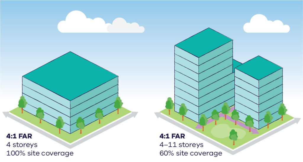
An example diagram of floor area ratios (FARs) showing two different storey buildings.
The Special Use Zone (SUZ) is the tool that will guide planning decisions on future land use planning applications. It allows development of land for uses that are specific and bespoke to the area.
In Arden, Schedule 7 to the SUZ, which has been specifically drafted for Arden, will encourage employment around the new Arden Station and allow a mix of uses to develop throughout the precinct, including residential development.
The zone will also introduce controls that manage amenity in the precinct, including noise and safety.
Most future planning applications will be exempt from future third party appeal and review under the Special Use Zone proposed for Arden. This means many planning applications for future developments in Arden will not be made available for public consultation before they are assessed for approval, so long as they abide by the planning controls.
A Design and Development Overlay identifies land that is affected by specific requirements relating to the design and built form of new developments. In Arden the Design and Development Overlays include controls for building heights, limiting overshadowing of public parks and other controls to ensure a high standard of design throughout the precinct.
There are four unique Design and Development Overlays proposed for the Arden Precinct, one tailored for each of the four sub-precincts identified in the Arden Structure Plan.
A Public Acquisition Overlay is a planning control that reserves land for a public purpose and indicates that this land could be compulsorily acquired in the future.
The approved planning scheme amendment includes a Public Acquisition Overlay to be applied to land in Arden that is necessary to deliver vital infrastructure.
An amenity buffer is used in planning to make sure sensitive land uses, like schools and residences, are not affected by odour or dust from industries operating nearby.
Amenity buffers are recommended by the Environment Protection Authority (EPA) in Arden because existing businesses may emit odour or dust as part of their operations.
The approved planning scheme amendment includes a Buffer Area Overlay in parts of Arden and its surrounds to manage the introduction of sensitive land uses around the asphalt plant at 208-292 Arden Street, operated by Citywide Service Solutions Pty Ltd.
The overlay adds additional controls to the planning scheme to carefully manage amenity for future sensitive land uses. This makes sure development appropriately responds to the existing asphalt plant while it continues to operate.
Find out more about buffers and land use compatibility at planning.vic.gov.au/policy-and-strategy/buffers-and-land-use-compatibility
An Environmental Audit Overlay is applied to land that may be affected by potential contamination.
The approved planning scheme amendment includes an Environmental Audit Overlay that applies to the whole precinct to allow for sensitive land uses, such as schools or residences, on land that is potentially contaminated land. The overlay will require further investigations be carried out by developers before sensitive land uses can be built.
More information on the use of the Environmental Audit Overlay can be found at environment.vic.gov.au/sustainability/victoria-unearthed/about-the-data/environmental-audit-overlay
A Parking Overlay identifies land that is subject to specific parking requirements.
There is already a Parking Overlay that applies to part of Arden. The approved planning scheme amendment includes an updated Parking Overlay to implement the Arden Precinct Parking Plan and proposed parking controls for Arden.
The proposed Parking Overlay for Arden provides car parking rates and aims to encourage the delivery of consolidated, precinct car parking, and discourage the provision of individual, on-site car parking.
Development contributions are payments or in-kind works, facilities or services provided by developers towards the supply of infrastructure required to meet the future needs of the community.
A Development Contributions Plan (DCP) sets contribution rates and outlines how future residents, visitors and workers will be provided with timely access to the services and infrastructure they need.
A Development Contributions Plan Overlay identifies the land that is subject to a DCP. The approved planning scheme amendment includes a Development Contributions Plan Overlay which supersedes the interim overlay and introduces new rates in accordance with the DCP.
The planning scheme allows local policy to guide planning decisions on specific areas that are important to the local community. The approved planning scheme amendment creates a new local policy for Arden that will promote employment opportunities including those in creative and innovative industries, sustainability, affordable housing and good quality urban design outcomes.
About Arden
The Arden Precinct is a 44-hectare urban renewal area located around the new Arden Station in North Melbourne.
Arden is proposed to be an employment and innovation precinct and a thriving new neighbourhood for Melbourne’s inner north-west. It aspires to accommodate approximately 34,000 jobs and be home to around 15,000 residents.
The precinct is bounded to the north by Macaulay Road, the east by Macaulay Road and Dryburgh Street and the south and west by existing railyards on the Upfield line.
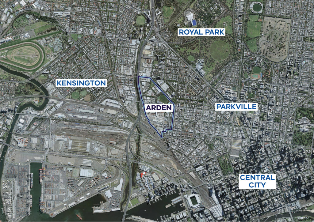
Map of the Arden Precinct and surrounding areas.
The Arden Vision was prepared by the VPA and City of Melbourne in 2018 following engagement with the community and key stakeholders. The Arden Vision sets eight key directions for Arden that lay the foundation for the Arden Structure Plan.
The Arden Structure Plan July 2022 sets the future direction for Arden over the next 30 years. It translates the eight key directions of the Arden Vision into 31 objectives supported by 109 strategies for implementation.
The Arden Structure Plan covers themes such as urban character, sustainability, transport, water, open space and community facilities and is implemented through the approved planning scheme amendment.
The heart of the precinct will develop into an employment and innovation hub with life sciences, health, digital technology and education sectors at its centre, advancing Melbourne’s strengths as a progressive, innovative and connected global city.
Arden will become a thriving inner-city neighbourhood surrounding the Metro Tunnel’s new Arden Station, featuring vibrant streets and open spaces, new schools and community facilities, innovative water management and well-designed buildings to live and work in, including affordable housing options. The well-connected streets will encourage people to get around by foot or bike. A proposed government primary school in Arden and proposed secondary school in the neighbouring Macaulay precinct will service the new community.
This change is expected to occur gradually over the next 20+ years.
Arden includes a variety of block sizes, from small, narrow residential lots to large industrial landholdings. The Victorian Government is the largest landowner, with significant landholdings around the new Arden Station. The remainder of the precinct is owned by private land and/or business owners.
The large government land ownership within the precinct is unique. It gives the precinct potential to transform in a coordinated way providing new streets and laneways, open spaces and parks and new infrastructure. It presents the opportunity for Arden to develop into an innovation precinct specialising in health, life sciences, digital technology, and education technology to complement Australia’s preeminent biomedical cluster in Parkville.
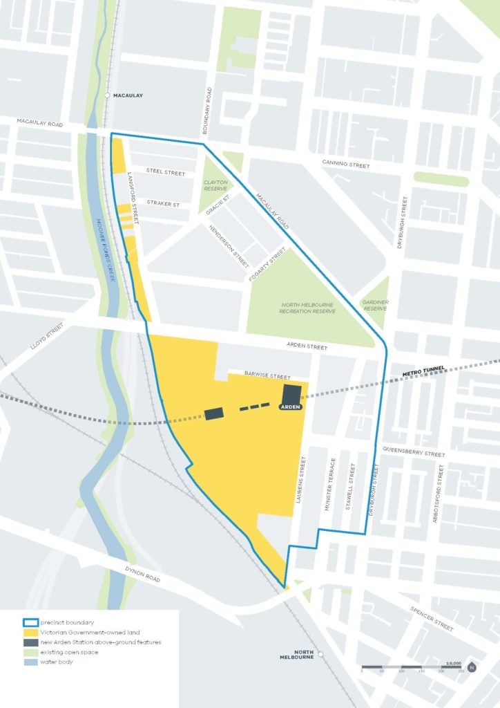
Map of the Arden Precinct showing government land holding and Arden Station.
The Arden Structure Plan outlines how the precinct will transform into an employment and innovation precinct and a thriving new neighbourhood centred around the Metro Tunnel’s new Arden Station.
It includes strategies and objectives to guide the nine key directions for Arden’s renewal:
- Transforming Arden: Advancing Melbourne’s strengths as a progressive, innovative, and connected local and global city
- Designing a distinctive place: Reflecting the identity and characteristics that make North Melbourne and West Melbourne special to residents and workers
- Embedding sustainable change: Leading in environmental, social, and economic sustainability
- Prioritising active transport: Providing direct and efficient connections in and around the precinct, anchored by the new Arden Station
- Celebrating water: Incorporating water as a visible feature of the landscape through innovative and creative flood management
- Creating diverse open spaces: Creating a cooler and greener version of the central city with multi-functional spaces for recreation, socialising, active transport and biodiversity
- Accommodating diverse communities: Providing for a diversity of households for a range of ages and incomes
- Investing in community infrastructure: Supporting the existing and new community
- Delivering Arden: Setting the framework for how Arden will be governed and develop over time
Arden’s transformation will be gradual and is expected to occur over decades as the precinct changes from a predominantly industrial precinct to a high-density employment and innovation hub. Depending on your relationship to the precinct, you will be affected by this change in different ways.
If you are a current business owner within the Arden precinct, the Department of Transport will be able to provide advice about the next steps for you. Arden’s renewal will generate opportunities for the government to support existing businesses that are undergoing change to review their future role in the precinct and, if required, potentially find more suitable locations as the precinct becomes a place for a mix of employment and residential uses, people-focussed streets, green spaces and plazas.
If you are a resident within the Arden precinct or in neighbouring suburbs, this planning will gradually change the area you live in over a long period of time. You will notice changes as the plan is realised through future development and significant investment in community infrastructure and new open spaces.
The interruption caused by building and development will only commence once the planning scheme amendment is gazetted and the planning permit approvals process for various developments has occurred.
The plans for Arden
Yes, the plans for Arden include cycling infrastructure to fill the gaps in the local cycling network to create a safer, protected, connected, and convenient network for all users.
The Capital City Trail along the Moonee Ponds Creek provides regional cycle access to the suburbs in Moonee Valley and Moreland (via Royal Park and the Upfield bike path) and on to Docklands, Footscray and Fishermans Bend. New cycling infrastructure constructed as part of the West Gate Tunnel Project will provide a shared path along Dynon Road from CityLink over the Moonee Ponds Creek and the rail corridor to Dryburgh Street.
There are four proposed Strategic Cycling Corridors (SCC) within Arden. All of the SCCs will provide fully protected bike lanes. These corridors are designed to improve cycling to and around major activity centres and are routes that cater for the highest cycling volumes while offering physical protection from cars so that people of all ages and abilities can confidently use bicycles to travel to the precinct.
A network of local cycling corridors will connect with the SCCs. These will also provide protected bike lanes and have been planned to minimise conflict with cars to maximise safety.
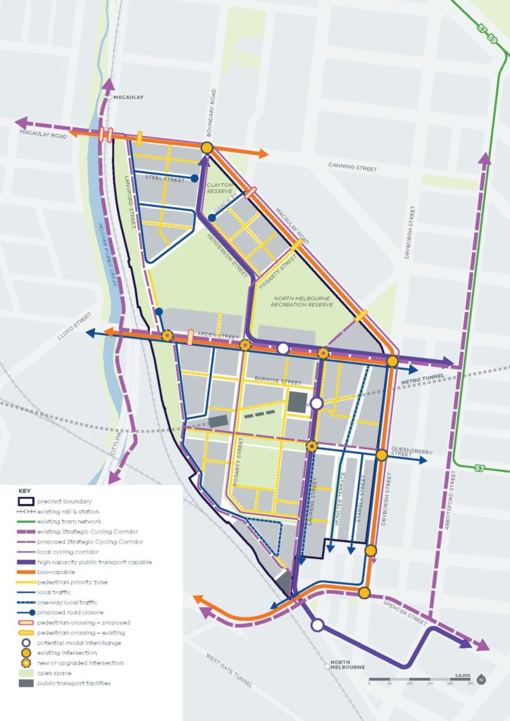
Map of the Arden Precinct showing the transport plan.
New infrastructure or upgrades to existing infrastructure will be funded by the Arden Development Contributions Plan, developer works or future Victorian Government cycling initiatives.
For more information on Arden’s transport and cycling strategy and the planning controls that relate to it, refer to Chapter 5 and Appendix 2 of the Arden Structure Plan and the Arden Precinct Cross Sections. For details on the cycling infrastructure, who will deliver it and how it will be funded, refer to Appendix 3 of the Arden Structure Plan and the Development Contributions Plan.
Arden’s transformation will be gradual, as the precinct changes from a predominantly industrial precinct to a high-density employment and innovation hub. We anticipate Arden’s development will occur over the next 30 years.
The approval and gazettal of amendment C407melb paves the way for building and development in the precinct to commence.
The precinct will become a focal point for the community of Melbourne’s inner north-west. The plans include places for people to live, work, meet and shop.
New open spaces will complement the existing 6.5ha of open space that includes North Melbourne Recreation Reserve and Clayton Reserve.
The draft planning scheme amendment proposes more than 9.09ha of new green open space and new community spaces including:
- A 3.65ha new open space in the north of the precinct that is designed to intentionally flood during major rain events to help manage stormwater, and serve as a sports field when dry
- A 1ha neighbourhood park in Arden Central
- A 0.66ha Capital City Open Space in the heart of the precinct next to Arden Station
- New green open spaces along streets and footpaths and the Moonee Ponds Creek that offer both recreation and flood management
- Two new community facilities providing for a variety of local services
- A proposed new primary school and potential future health institution
In total, open space will account for around 28 per cent of land within the precinct.
Built form controls will protect parks and open spaces in Arden from impacts like overshadowing and wind.
These community facilities and open spaces will be delivered by the Victorian Government and City of Melbourne, or by developers via the Development Contributions Plan.
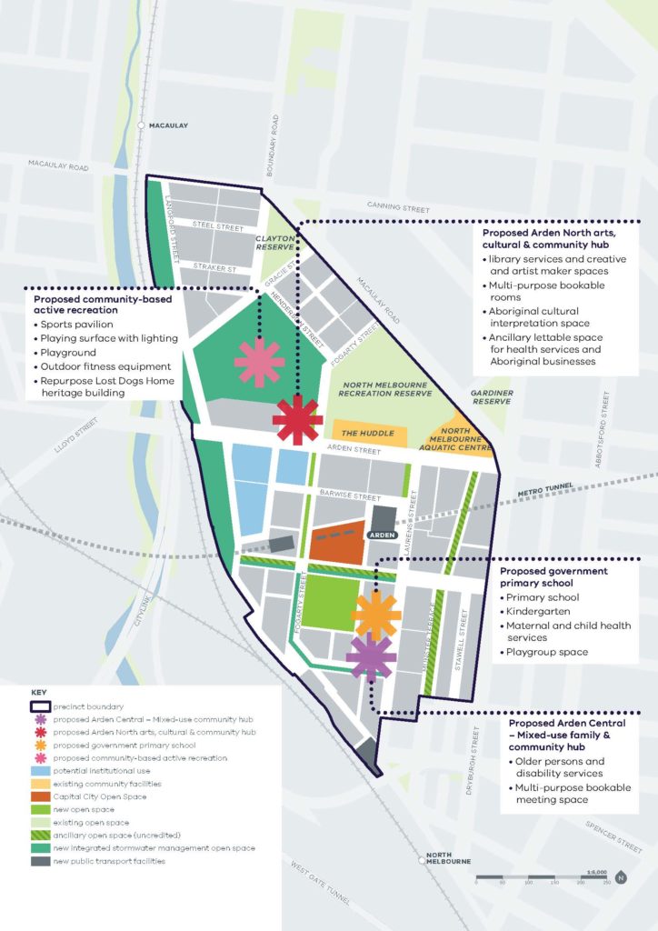
Map of the Arden Precinct showing open space and community facilities.
For more information on Arden’s new open spaces and community infrastructure refer to Chapter 7 and 9 of the Arden Structure Plan. For details on who will deliver it and how it will be delivered and funded, refer to Appendix 3 of the Arden Structure Plan and the Development Contributions Plan.
The approved amendment supports and encourages the provision of at least six per cent of new dwellings in Arden to be affordable housing.
The Arden Structure Plan and amendment C407melb include the following Victorian Government and City of Melbourne delivery strategies:
- Support and encourage the provision of six per cent affordable housing in new developments to be delivered at 50 percent (or alternative method of the equivalent value) discount to a registered housing association.
- Require that up to 25 per cent of new housing be made available as affordable housing where City of Melbourne-owned land is redeveloped.
- Encourage additional affordable and social housing provision on all types of land to achieve goals.
- Require that at least five per cent of all private housing be universally accessible, to encourage assisted living and help residents age in place.
- Facilitate a diversity of sizes of residential accommodation for all types of households.
Transport planning for the precinct is focussed on delivering great streets and public spaces to make walking and cycling the most convenient ways to move around the precinct and access daily needs. The precinct plans have been designed to achieve the following principles:
- Create a pedestrian-friendly public realm that is safe, comfortable and convenient to maximise patronage from Arden Station, and between existing Macaulay and North Melbourne Stations.
- Reduce rat-running by cars through the precinct.
- Manage vehicle circulation, calm local traffic speeds and control supply and location of car parking.
- Promote cycling in Arden by connecting to regional cycle paths and trail networks and providing a safe network that encourages cyclists of all ages and abilities.

Map of the Arden Precinct showing the transport plan.
Together, these principles will support the target of net zero carbon emissions by 2040 and improve the quality of the public realm by making it easier for people to choose to walk, cycle or catch public transport instead of drive.
For more information on Arden’s transport strategy refer to Chapter 5 of the Arden Structure Plan. For details on transport infrastructure, who will deliver it and how it will be funded, refer to Appendix 3 of the Arden Structure Plan and the Development Contributions Plan.
Parking in Arden will be controlled by innovative new planning controls and supported by the Arden Precinct Parking Plan.
The proposed schedule to the Parking Overlay sets preferred maximum car parking rates aimed to discourage individual onsite parking, and encourage consolidated, publicly available car parking.
Car park facilities will be encouraged to provide a diverse range of parking options, including conveniently located disability parking, pick-up / drop-off spaces, car share spaces, bicycle parking, and loading bays. Car parks will also be encouraged to be equipped for electric vehicle charging.
The Arden Precinct Parking Plan will also manage the amount of on-street parking and how it is used.
This approach encourages more efficient use of car parking spaces as they can serve different uses at different times, e.g. the same parking space can serve a worker during the day and a resident at night. It also makes Arden a more inviting and people-friendly neighbourhood by reducing the amount of public space taken up by parked cars, and reducing the number of large parking structures. The plan supports sustainable transport choices while ensuring there is still parking for those who need it such as families, people with disabilities, or workers dependent on cars.
The Arden Precinct Parking Plan outlines the preferred movement network, identifies car parking rates and recommends an approach to car parking to inform the Arden Structure Plan.
Vehicle access will be directed to the edges of the precinct, and access to car parking restricted to Arden’s primary vehicle roads. This is to ensure room for people is prioritised over room for cars around Arden’s core pedestrian spaces.
If you have an existing parking permit in Arden, it will not be removed by this planning process.
For more detail on Arden’s transport and car parking strategy and the planning controls that relate to it, refer to Chapter 5 of the Arden Structure Plan, the Parking Overlay and Arden Precinct Parking Plan.
New density and built form controls will transform Arden to a new and distinctive part of the city, while being sensitive to the existing built form and character of North Melbourne. The planning controls will require development to meet high quality design standards.
The building heights range from low to mid rise development (up to 15 storeys) to transition from the lower heights of North Melbourne, stepping up to high rise (16 storeys and taller) where appropriate. The tallest buildings (up to 40 storeys) are placed along the rail corridor and CityLink.
These controls are discretionary in Arden Central and some parts of the Laurens Street sub-precinct, meaning a developer would have to justify why exceeding the controls would not negatively impact the precinct.
The built form will redefine the skyline of this part of Melbourne. Arden’s taller skyline will stand out from the stretch of low to mid-rise development surrounding it.
Built form controls have been strengthened since the draft Structure Plan to ensure they manage impacts including overshadowing of key public spaces and mitigating wind effects caused by tall buildings.
Built form controls include street wall height limits and setbacks from both the street and neighbouring sites. They also encourage laneways and through block links for larger blocks to encourage walkability.
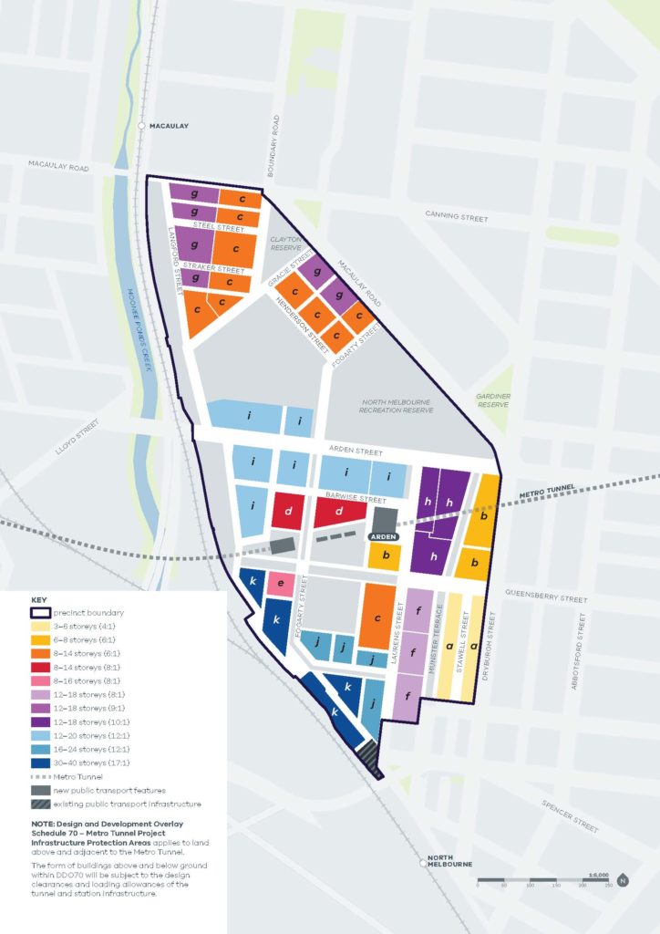
Map of the Arden Precinct showing built form planning controls.
For more detail on Arden’s built form strategy and the planning controls that relate to it, refer to Chapters 2 and 3 of the Arden Structure Plan and the Design and Development Overlays DDOs) for each sub-precinct.
Built form controls will protect Arden’s open spaces from overshadowing at important times of day.
In Arden Central, no additional overshadowing above the shadow cast by the preferred maximum street wall heights is allowed between 11am and 2pm in winter. In Arden North, no additional overshadowing above the existing conditions is allowed between 11am and 2pm in Spring.
This means any proposed building must allow sunlight access according to these rules, regardless of its height.
No overshadowing controls have been proposed in the Laurens Street sub-precinct as the lower building heights will have less of an impact on open spaces.
For more detail on Arden’s built form strategy and the planning controls that relate to it, refer to Chapters 2 and 3 of the Arden Structure Plan and the Design and Development Overlays for each sub-precinct.
Melbourne Water has prepared a drainage strategy to manage the impacts of flooding. It aims to ensure that local stormwater runoff and riverine flooding from the Moonee Ponds Creek and surrounding areas can be managed as safely as possible at a precinct-wide level and allow for the development of other land in the precinct.
Water will be a positive, visible feature of the precinct, including along Arden Street, Queensberry Street and Fogarty Street. Visible stormwater management measures will slow and store stormwater and support ecology and biodiversity in Arden while celebrating water in the landscape.
A central feature of the precinct will be a new integrated stormwater management open space in the precinct’s north which will be designed to flood during major rain events while also providing for active recreation and biodiversity, and opportunities for surrounding community and cultural uses.
Water storage areas to the west of Langford Street in and along the Upfield railway corridor will provide green open spaces, supporting urban greening and cooling.
The Arden Development Contributions Plan and Melbourne Water’s separate Urban Renewal Cost Recovery Scheme (URCRS) will fund the necessary infrastructure, land acquisition and basic improvements to open spaces to support the drainage strategy.
The City of Melbourne is also working on a separate amendment to introduce a Land Subject to Inundation Overlay and Special Building Overlay to guide new development being designed with flood resilience in mind. See the ‘Related Projects’ FAQs for more information.
For more information on Arden’s integrated water management strategy refer to Chapter 6 of the Arden Structure Plan. For details on the drainage infrastructure, who will deliver it and how it will be funded, refer to Appendix 3 of the Arden Structure Plan and the Development Contributions Plan.
Sustainability is embedded in every element of the plan including transport, building design, water management and open space. Sustainability will be a highly visible and celebrated part of the identity of Arden.
The planning controls set a target of net zero carbon emissions for the entire Arden precinct by 2040 and encourage 6 Star Green Star energy ratings for new developments.
Better building practices will reduce the costs of owning and operating buildings, reduce the cost of expensive future retrofits, and reduce the need to purchase carbon offsets. Local planning policy provides guidelines for achieving certification to a 6 Star Green Star rating.
The result will be a precinct that achieves a cool, green environment, celebrates water in the landscape, demonstrates world leading building design and has a visible connection with nature and reference to its historical landscape.
For more detail on Arden’s sustainability strategy and the planning controls that relate to it, refer to Chapter 4 of the Arden Structure Plan and Arden Urban Renewal Area Policy.
The planning controls require development in Arden to fit the character and vision for Arden’s four distinct sub-precincts. They also ensure building heights in sensitive areas are appropriate and transition to the scale of the existing neighbourhood.
Feedback from past community engagement expressed the importance of creating relaxed, informal places within Arden where people can gather, relax, or exercise. To achieve this, the plan encourages a diversity of activities at street level (such as cafes or co-working spaces) to create a vibrant atmosphere that is safe, interesting, and inclusive.
Reflecting and respecting the heritage of the area was also seen as a key to ensuring that the precinct develops as a cohesive neighbourhood.
Existing heritage controls will protect heritage buildings throughout the precinct, which will offer opportunities for sensitively designed adaptive reuse of these spaces so that they continue to offer value to the future local identity.
While the draft planning scheme amendment does not include a new heritage overlay, our design controls reflect existing heritage controls, so any new development must give regard to heritage. For more information on heritage in Arden, refer to Chapter 2 of the Arden Structure Plan.
We have developed sub-precinct character descriptions to articulate a distinct identity for each sub-precinct. For more information on the desired character for each sub-precinct and the controls to achieve them, refer to the Design and Development Overlays.
Funding and delivering Arden
The Arden Development Contributions Plan (DCP) outlines how future residents, visitors and workers within Arden will be provided with timely access to the services and infrastructure they need.
The DCP rate is based on the estimated construction and land costs for required infrastructure projects. These costs are divided by the anticipated yield for the precinct to determine the rates for residential, commercial and retail development.
The DCP establishes a framework for developers to make financial contributions toward the cost of Arden’s key infrastructure, and provides certainty to developers, investors, and local communities about development contribution requirements and how they will be administered.
This plan requires developers to contribute towards $350 million worth of infrastructure, complemented by significant government investment, open space contributions, developer works and Melbourne Water’s Urban Renewal Cost Recovery Scheme.
The Arden DCP proposes a contribution rate that is less than the estimated cost of infrastructure. The Victorian Government takes responsibility for the difference between these amounts, the appropriation of which will need to be managed as part of future infrastructure funding commitments.
The draft planning scheme amendment includes a Development Contributions Plan Overlay which would supersede the Interim Development Contributions Plan Overlay currently in place and introduce new rates.
Below is a summary of the key charges.
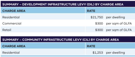
Development Contributions Table – 2022
Open space contributions
A person who proposes to subdivide land must make a contribution to the council for public open space. The contribution must be 7.06% of the land intended to be used for residential, industrial or commercial purposes, or a percentage of the site value of such land, or a combination of both in line with Clause 53.01 of the Melbourne Planning Scheme.
For more detail on Arden’s infrastructure funding refer to Chapter 10 and Appendix 3 of the Arden Structure Plan, the Development Contributions Plan and the Development Contributions Plan Overlay. For more detail on open space contributions refer to the Special Use Zone.
The Urban Renewal Cost Recovery Scheme (URCRS) is Melbourne Water’s cost recovery program for investments in critical flooding and drainage assets required to support major urban renewal in the Arden precinct.
The URCRS is a separate charge to the Development Contributions Plan (DCP). Melbourne Water has worked closely with the Victorian Planning Authority, Department of Transport and City of Melbourne to ensure all drainage works are funded appropriately through the URCRS and DCP without any overlap between the two charges.
Melbourne Water will run a separate engagement process on its URCRS, where it will provide further information on assets, locations and charges in the Arden precinct.
For more information, visit melbournewater.com.au/urcrs
The Victorian Government will have to acquire some land in Arden to support stormwater management and create the proposed street network. The draft planning scheme amendment includes a Public Acquisition Overlay to be applied to land necessary to deliver this vital infrastructure.
The Department of Transport (DOT) is engaging directly with all landowners affected by the proposed Public Acquisition Overlay on behalf of the Victorian Government.
Related Projects
Development staging guidance
The Victorian Planning Authority (VPA) has published a new guidance note for Infrastructure and Development […]

Draft Arden Vision & Framework – Community Engagement for Phase 1 has Concluded
The first phase of community engagement on the Draft Arden Vision & Framework has now […]
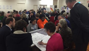
Arden community and business forums provide food for thought
The VPA was delighted to host two public engagement forums last week for the Arden […]
