Ballarat North
The Victorian Planning Authority (VPA) and Ballarat City Council are working in collaboration to prepare the Ballarat North Precinct Structure Plan (PSP), Native Vegetation Precinct Plan (NVPP), and Development Contributions Plan (DCP). The PSP area is approximately eight kilometres north of the Ballarat Central Business District.
The Ballarat North PSP area has been rezoned to the Urban Growth Zone (UGZ). The Environmental Audit Overlay (EAO) has also been applied to part of the land at 15 Olliers Road, Mount Rowan and Noble Court, Mount Rowan. However, no immediate urban development can take place until a PSP and DCP have been finalised and implemented into the Ballarat Planning Scheme.
To inform preparation of the PSP, the area that has been rezoned has been the subject of strategic technical assessments and engagement with landowners and relevant agencies over several years by Council.
An area to the north of the PSP (north of Cummins Road), will remain in the farming zone until additional greenfield land is needed at which time a PSP will be prepared. To ensure that the appropriate infrastructure and services are provided for the entire northern growth area, it is noted that some technical work prepared for the Ballarat North PSP has considered the additional area to enable it to be ‘future-proofed’.
The Standing Advisory Committee has concluded
The VPA will now finalise the Ballarat North Precinct Structure Plan (PSP), Native Vegetation Precinct Plan (NVPP), and Development Contributions Plan (DCP) for ministerial consideration.
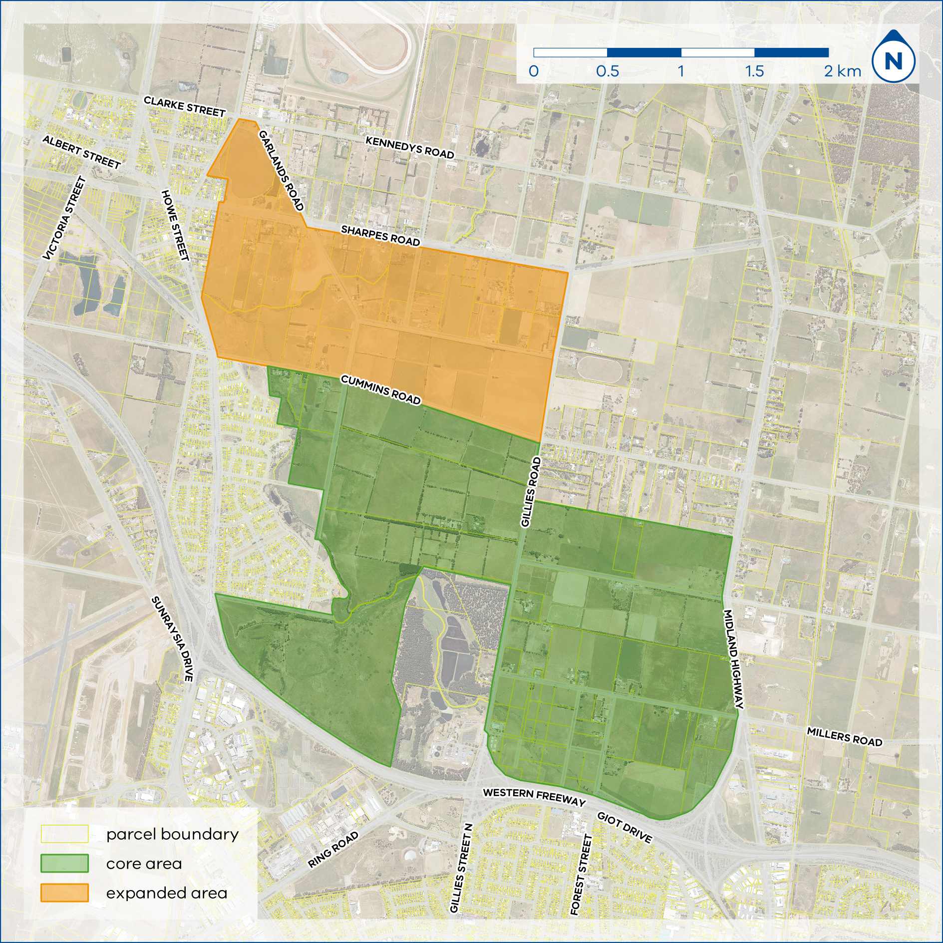
A map displaying the Ballarat North core and expanded areas
Mount Rowan surrounded by farmland
Background information
The Victorian Planning Authority (VPA) is a State Government statutory authority within the Department of Transport and Planning that reports to the Minister for Planning.
The VPA’s main task is to make sure Melbourne and Victoria’s regions remain great places to live and work. This requires vision and long-term planning to ensure our growing population has equitable access to employment, public transport, attractive public spaces and affordable housing.
Our key priorities include unlocking land for new homes and communities, facilitating housing diversity and affordability, job creation and better development of new communities in growing and established areas.
We do this by working closely with councils, government agencies and the planning and development community on integrated land use and infrastructure coordination for new communities and strategically important precincts.
A Precinct Structure Plan (PSP) is a high-level strategic land use and infrastructure plan.
A PSP normally identifies the potential location of housing, retail, parks, drainage corridors, schools, signalised intersections, higher order roads and other land uses.
The PSP sets out the intended future land uses, and infrastructure outcomes which would ultimately be reflected by subdivision and development applications submitted and approved through Council once the PSP is approved.
A Development Contributions Plan (DCP) identifies the costs of some essential infrastructure required to support a PSP such as the costs of signalised intersections, drainage corridors, retarding basins, and others. It will also set out a levy required for new development on a ‘per hectare of net developable area’ basis.
The DCP is required since broad scale new development often contribute to or cause the need for new or upgraded infrastructure. It ensures that existing infrastructure is not over-burdened by new development.
The DCP will be prepared concurrently with the PSP. All infrastructure items included must be strategically justified through a suite of background studies undertaken on the project. The DCP becomes a public document to be publicly exhibited along with the PSP.
Third party funding is the method adopted by the VPA to fund the preparation of a Precinct Structure Plan (PSP) and Development Contributions Plan (DCP). Funding will facilitate the preparation or updates to technical work, stakeholder consultation, and associated work to prepare a planning scheme amendment to incorporate the PSP and DCP into the Planning Scheme.
Third Party Funding Agreements are a contract between the VPA and a ‘third party’ (typically the landowner) to formalise funding arrangements. Typically, costs to fund a PSP is undertaken on a per hectare basis (i.e. the larger your landholding the more it will cost). The Agreements provide for staged payments over the course of the PSP process.
Third party funding is voluntary.
Normally, third party funding costs are estimated by undertaking the following steps:
- Project is scoped to determine complexity and range of issues that will need to be addressed by the PSP (including required technical studies).
- The VPA calculates the total estimated cost of the project, with estimates based on previous (most recent) actuals with allowances for variances based on inflation and the relative complexity of the project.
- The estimated total cost of project is divided by the area of the precinct to deliver a per hectare funding rate.
- The VPA then seeks Expressions of Interest from all landowners within the precinct to enter into Third Party Funding Agreements with requested amounts based on the calculated per landowner funding amount.
- Following receipt of Expressions of Interest from landowners the VPA will recalculate each landowner’s draft obligation and provide this back to participating landowners to confirm their continued interest.
Project information
The Commons are recognised as an important community and environmental asset and are not proposed to be redeveloped as part of the structure plan.
Depending on the availability of funding through the Development Contributions Plan, the Town Commons may be improved to better recreational amenity and recognise the community and cultural values of the area.
The Ballarat North precinct is split into two keys portions: the ‘core area’ and ‘expanded area’.
The area that has been rezoned is referred to as the ‘core area’ and was identified through the Ballarat Long Term Growth Options Investigation Paper, 2018, which assessed the area as being largely available for development, subject to a PSP. The unzoned area to the north is referred to as the ‘expanded area’ of the precinct and was identified later, following Council’s public consultation on the Long Term Growth Options Investigation Paper.
The Ballarat North PSP will proceed focusing only on the area referred to as the core area. The expanded area will remain in the farming zone until additional greenfield land is needed. However, it is expected that the expanded area will become a growth front for future potential development.
A map displaying the Ballarat North core and expanded areas
The purpose of this project is to unlock developable land in Ballarat’s northern growth area.
Ballarat is experiencing strong population growth, increasing demand on housing and land supply. Strategic planning in Victoria aims to ensure there is 15 years of land supply available. The supply can be met with a combination of greenfield, urban renewal and infill sites.
The City of Ballarat requested the Minister for Planning formally appoint the Victorian Planning Authority to lead the preparation of the Ballarat North PSP. The Minister supported the request and appointed the VPA as the Planning Authority on 31 August 2022. The VPA will continue to work closely with the City of Ballarat and other agencies throughout the PSP process.
The ‘core area’ of the precinct is to be rezoned to Urban Growth Zone (UGZ), as directed by the Minister for Planning ahead of the PSP being prepared.
The purpose of the UGZ is to manage the transition of non-urban land into urban land and provides for a range of future land uses. There has been significant strategic assessment of the ‘core area’ and technical assessments have confirmed the area can be planned through a PSP.
The ‘expanded area’ is yet to undergo the same level of strategic assessment which will determine the final expanded area boundary. Given this technical work is not complete for the expanded area, it would be premature to rezone this portion of the PSP area to UGZ.
The Department of Environment, Land Water and Planning (DELWP) (now the Department of Transport and Planning (DTP)) were instructed by the Minister for Planning to rezone the core area to Urban Growth Zone (UGZ) ahead of the precinct structure plan (PSP) being prepared. The UGZ will be introduced via 20(4) of the Planning and Environment Act 1987 and will give affect to the PSP once the PSP is approved and gazetted.
This rezoning is underway and is led by DTP whilst the PSP is being led by the Victorian Planning Authority (VPA).
The Victorian Planning Authority (VPA) is collaborating with Ballarat City Council to prepare strategic planning outputs. A governance structure has been established including the City of Ballarat and other key government agencies to ensure collaborative decision making throughout the development of the PSP.
Once a project is completed, the Responsible Authority for implementing it over many years (e.g. approving subdivision applications) will usually be the local council. To assist in facilitating this, the VPA ensures regular engagement with council throughout the whole life of the project.
As part of the PSP process, thorough technical assessments and spatial analysis of the precinct must be undertaken. Access to your land will be required to undertake these important background technical studies to inform the PSP. The VPA request access to land is within the precinct, regardless of if landowners are interested in contributing third party funding to the project.
Access remains entirely at the landowner’s discretion, however, failure to grant access may lead to future costs for the landowner at the time of development, or uncertainty associated with satisfying statutory requirements when developing. If you wish to provide consent for the VPA or its representative to access your land, please complete the Consent to Access Land for Land Assessments form (Word) and return it to a project contact. The form can be emailed by sending a photo of the completed form to the project team.
The Ballarat North Water Reclamation Plant is located directly south of the precinct, adjacent to the Western Freeway. The Plant is not included within the precinct. There is an existing amenity ‘buffer’ surrounding the plant, which is implemented through the Environmental Significance Overlay – Schedule 4 in the Ballarat Planning Scheme. This project does not propose any changes to the existing buffer and new sensitive land uses will likely continue to be avoided within this buffer area.
The expanded area of the precinct boundary will be determined based on the strategic and technical assessments of the land. Once the expanded PSP boundary has been determined, the VPA will notify landowners.
Landowners within the precinct are also encouraged to register your interest on the project website to receive regular updates on the progress of the project, including the information on the final precinct boundary once determined. Landowners may also contact members of the project team if they would like further information.
Throughout the entire PSP process the VPA are actively engaging with the Registered Aboriginal Party for the area; the Wadawurrung Traditional Owners Aboriginal Corporation (WTOAC).
The PSP process will include a Cultural Values Assessment which will identify the cultural heritage values associated with the precinct and provide recommendations to inform the recognition of these values through the structure plan and subsequent development.
The project is to be undertaken through the PSP 2.0 process. This process offers several opportunities for landowners and agencies to contribute to the development of the PSP. The VPA project team will facilitate a series of workshops throughout the process, which provide opportunities to pitch ideas for precinct outcomes, contribute the project visioning and design ideas. The best way to stay updated with the PSP process and get involved in upcoming workshops is to sign-up to our newsletter by entering your details into the Subscribe now fields on the right of screen.
The wider community will be able to engage in this process at the public exhibition phase. At the public exhibition phase everyone is invited to provide comment on a Draft Precinct Structure Plan and Development Contributions Plan. All concerns will be considered, if they cannot be resolved these concerns can be referred to an independent Planning Panel who will make recommendations to the VPA on how best to move forward.
The Burrumbeet Creek is identified as a key environmental feature of the area. An Integrated Water Management and Drainage technical assessment will be undertaken as part of the preliminary technical studies. These consultant–led assessments will model potential flood impacts and inform design outcomes which provide community resilience to flooding.
A range of detailed technical assessments will be undertaken as part of the PSP process. Many of these assessments will have a strong environmental focus, identifying existing site features and recommending management or conservation approaches through development delivery. These studies include biodiversity, arboriculture, bushfire, land capability, geoscience and landscape assessments. The outcomes of these reports will inform the project outputs and ensure a high quality of ecological outcomes.
Infrastructure will be delivered as development progresses in the precinct once the PSP is finalised.
Important infrastructure needed to support the PSP will be identified through a Development Contributions Plan (DCP) prepared concurrently with the PSP.
Once the PSP is finalised and planning applications are made to Council to subdivide and develop land, the landowner or developer would pay contributions based on the levy set out in the DCP or have the option undertake or works-in-kind towards the provision of infrastructure in-lieu of cash contribution.
The Land Subject to Inundation Overlay (LSIO) is applied to land which has been identified as flood prone by the floodplain management authority, which is the Glenelg Hopkins Catchment Management Authority in the Ballarat region. The purpose of the overlay is to ensure development effectively responds to the flood hazard and will not cause any significant rise in flood level.
The Floodway Overlay (FO) is applied to land which is considered high risk of being affected by flooding. The purpose of the overlay is to ensure any development is compatible with the flood hazard, allowing the free passage of floodwater while minimising soil erosion and risks to waterway health.
In the Ballarat North precinct, the LSIO and FO affect land directly adjoining the Burrumbeet Creek. The VPA is currently preparing a precinct structure plan (PSP) for the precinct, however these existing overlays will remain during plan preparation and once the plan is complete.
Any planning permit application (including subdivision applications), where land is affected by the LSIO or FO, is required to demonstrate the objectives of the overlay are appropriately met. That may include submission of a flood risk report, development plans which identify the site contours, proposed finished floor levels and other relevant information. Applications will be assessed by Glenelg Hopkins Catchment Management Authority, through a formal referral and only supported where the flood hazard can be appropriately managed.
The Environmental Audit Overlay (EAO) is applied to land which has been identified as potentially contaminated. The aim of the overlay is to ensure future land uses adversely affected by any contamination.
The VPA is currently preparing a precinct structure plan (PSP) for the precinct, which involves undertaking a range of technical assessments of the precinct. The land capability assessment considers historic and current land uses and potential risk of land contamination.
The EAO currently only affects a small portion of land in the southeast of the precinct, adjoining the Midland Highway. However, should the findings of the land capability assessment identify other areas which have potential for contamination, the overlay may be applied to additional parcels within the precinct.
The EAO does not always prohibit future development, however, prompts further investigation of potential contamination before development can occur. When the PSP is complete, landowners who wish to develop their properties (in accordance with the PSP) will need to apply for a planning permit with the City of Ballarat. Where a sensitive land use is proposed on land which the EAO applies, landowners would be required to undertake a preliminary risk screen assessment. This assessment would determine the level of contamination and if any further investigation or remediation works are required, though an environmental audit process.
The Environmental Significance Overlay (ESO) is applied to land where development may be affected by environmental constraints or be incompatible with existing environmental values.
In the Ballarat North precinct, Schedule 4 to the ESO applies to land adjoining the Ballarat North Wastewater Treatment Plant. The purpose of this specific schedule is to provide a buffer area around the plant, preventing development which may have a detrimental impact on the operation of wastewater treatment.
The VPA is currently preparing a precinct structure plan (PSP) for the precinct, however no change to this overlay is proposed as part of this process. When the PSP is complete, landowners who wish to develop their properties (in accordance with the PSP) will need to apply for a planning permit with City of Ballarat.
Where an application for development within this overlay is proposed, it must demonstrate there would be no detrimental impact on the operation of the plant. The City of Ballarat would assess this as the responsible authority.
The Erosion Management Overlay (EMO) is applied to land which has been identified as prone to erosion, landslip, or other land degradation. The overlay aims to minimise land disturbance and inappropriate development in these areas. In the Ballarat North precinct, the EMO affects some land directly adjoining the Burrumbeet Creek in the northwest and areas surrounding Mount Rowan in the northeast of the precinct.
The VPA is currently preparing a precinct structure plan (PSP) for the precinct, however this existing overlay will remain during plan preparation and once the plan is complete.
Any planning permit application (including subdivision applications), where land is affected by the EMO, is required to demonstrate the objectives of the overlay are appropriately met. That may include submitting additional information on existing site conditions, the extent of proposed earthworks and/ or stabilisation methods. Based on the information provided, the City of Ballarat as the responsible authority will determine if the risk of erosion can be effectively managed.
The Bushfire Management Overlay (BMO) is applied to land where the bushfire hazard requires bushfire protection measures to be implemented. The overlay aims to ensure development is only permitted where risk to life and property from bushfire can be reduced to an acceptable level.
In the Ballarat North precinct, the BMO affects some land directly adjoining the Ballarat North Wastewater Treatment Plant, directly to the south of the precinct.
The VPA is currently preparing a precinct structure plan (PSP) for the precinct, however the existing BMO will remain during plan preparation and once the plan is complete.
When the PSP is complete, landowners who wish to develop their properties in accordance with the plan will need to apply for a planning permit with the City of Ballarat. Any planning permit application (including subdivision applications), where land is affected by the BMO, is required to be accompanied by:
- A bushfire hazard site assessment
- A bushfire hazard landscape assessment
- A bushfire management statement
All applications will be assessed by the Country Fire Authority, through a formal referral from the City of Ballarat. Development can only be supported where the bushfire risk can be reduced to an acceptable level.
The Design and Development Overlay (DDO) is applied to land where specific development requirements are needed. In the Ballarat North precinct, schedule 18 to the DDO is applied, affecting a portion of the precinct in the southwest. This schedule relates to development which may encroach on the Ballarat Airfield, which is located to the southwest of the precinct. The purpose of the overlay is to prevent development which may create obstacles in the flight path and ensure the ongoing safe operation of the airfield.
Assessment against this overlay is only required where the proposed building height is more than 15 metres.
Any planning permit application where development is proposed to have a building height of 15 metres, or more is required to demonstrate the development would not interfere with the operation of the airfield. The City of Ballarat as the responsible authority, in consultation with the Ballarat Aerodrome, would determine if the development is an acceptable outcome based on the information provided.
Having your say
Submissions provided to the Victorian Planning Authority are part of an open public process where all parties affected by the planning scheme can provide input into the draft amendment.
If you choose to make a submission, you consent to your submission being made public, and being identified as the author of the submission.
Your submission will be made available for public inspection on the VPA website until two months after gazettal of the resulting planning scheme amendment and will also be made available to relevant Ministers and local councils, and other involved government agencies.
If you are a private individual, your personal information will be removed from your submission before it is released to parties outside government or local councils. Contact details do not include the address of land which is the subject of your submission.
By making a submission, you also give permission for copyright material to be copied and made public.
How can I get involved?
The best way to stay involved in the plan development process is to register your interest in the project on the project website. If you would like to learn more, feel free to contact members of the project team and sign-up to our newsletter by entering your details into the Subscribe now fields on the right of screen.
Project overview
A precinct structure plan (PSP) is a land use and infrastructure plan to guide the development of an area over time. It gives certainty for community members and developers by providing a long-term vision for how an area will develop into the future.
A PSP sets out the preferred locations of residential and employment land and infrastructure while providing guidance for transport and parking, urban design, heritage and character, open spaces and integrated water management.
Together with the broader planning framework, precinct structure planning is an important part of the Victorian Government’s strategy to address population growth, housing and employment demands.
A planning scheme amendment involves either a change to a planning scheme map, a change to the written part of the scheme, or both.
Amendments to a planning scheme can have significant planning implications as they change the way land can be used or developed, thereby changing the basis of planning decisions in the future.
The draft amendment C256ball specifically proposes to:
- Insert the Ballarat North Precinct Structure Plan in a new schedule to the Urban Growth Zone (UGZ)
- Insert the Ballarat North Development Contributions Plan in a new schedule to the Development Contributions Plan Overlay (DCPO).
- Inserts the Ballarat North Native Vegetation Precinct Plan in the Schedule to Clause 52.16 Native Vegetation Precinct Plan of the Ballarat Planning Scheme.
- Delete parts of the Floodway Overlay (FO) applied to land within the south-east corner of the precinct and replace it with the Land Subject to Inundation Overlay (LSIO) to allow for development.
- Apply an Environmental Audit Overlay (EAO) to land identified as having high risk for potential contamination
- Removes existing EAOs from land that has been identified as having low or medium risk for potential contamination
- Apply the Heritage Overlay to five places (three on Olliers Road, one on Gillies Road, and one on Sims Road)
- Apply the Public Acquisition Overlay (PAO) to some land required for future drainage assets
A development contributions plan (DCP) establishes a framework for developers to make a financial contribution towards the cost of key infrastructure projects, providing certainty for the future community around infrastructure timing, funding and delivery.
Developers will contribute towards necessary projects such as road infrastructure, drainage, sports reserves and community facilities through a per hectare rate or Development Infrastructure Levy.
Together, the PSP and DCP will provide a broad framework that will coordinate development and assist in the transition of the area from its current farming land and rural character into an urban residential area for Ballarat North.
An Environmental Audit Overlay (EAO) is applied to land that may be affected by potential contamination.
The draft planning scheme amendment includes an EAO that will be applied to properties within the precinct nominated as having potentially high risk of contamination.
Where a sensitive land use is proposed on land which the EAO applies, landowners would be required to undertake a preliminary risk screen assessment. This assessment would determine the level of contamination and if any further investigation or remediation works are required, though an environmental audit process.
The Heritage Overlay (HO) is applied to identified heritage places where planning controls are required to conserve and enhance its significance. If you have a HO on your property, you will likely need to apply to council for a planning permit for certain types of building and works. This is to ensure that the proposed development does not detract from the heritage significance of the place.
The Public Acquisition Overlay (PAO) is applied to identified land to reserve it for a public purpose and indicates that this land could be compulsorily acquired in the future. If a PAO applies to your land, and you wish to undertake certain building and works (such as building a shed), a planning permit may be required from council. To have a better understanding of what you can and cannot build upon land impacted by a PAO, speak directly with council.
A PAO does not expire; they are placed on land until that land is required for its intended purpose. In the future, it may be determined that your land is no longer required for the intended purpose, the PAO could be removed.
The Victorian Planning Authority (VPA) is responsible for the planning of new suburbs and renewal sites in Victoria. The VPA is the designated planning authority for draft amendment meaning that it is responsible for this amendment.
The VPA reports to the Minister for Planning while working closely with City of Ballarat, government agencies and the community on integrated land use and infrastructure coordination for important development sites and precincts.
Our key priorities include unlocking land for new homes and communities, facilitating housing diversity and affordability, job creation and better development of new communities in growing and established areas.
The PSP has been prepared with the VPA Precinct Structure Planning Guidelines: New Communities in Victoria (2021) and PSP 2.0 process.
As part of this process, the VPA is leading the preparation of the PSP and planning controls for the precinct in consultation with the City of Ballarat. The VPA is facilitating a whole-of-government approach which includes consulting with all relevant stakeholders, including state government agencies, council, landowners, Traditional Owners and local residents and businesses.
For more detail on the planning process to date, including the extensive research and analysis that has been undertaken, please see the background report.
Managing Key Concerns
The VPA commissioned Jacobs to undertake a transport assessment for the precinct to test the proposed new roads and projected traffic demand on the Ballarat transport network.
To support safe and smooth movement within and around Ballarat North, the PSP will assist with the delivery of the following transport infrastructure:
- A street network that will support local traffic and will be designed to be able to accommodate future bus routes.
- Upgrades to existing roads such as Gillies Road and Midland Highway to allow for more safe and efficient traffic movement and provide improved connections to Ballarat and surrounds.
- A bridge upgrade across Burrumbeet Creek at Cummins Road to connect the PSP and Miners Rest
- An extensive network of walking and cycling pathways that connects parks, sports reserves, schools and other key destinations.
Current and future residents will benefit from the following inclusions of the Precinct Structure Plan:
- Two new government primary schools and a government secondary school to service the wider community.
- Two community facilities.
- A large Neighbourhood Activity Centre and a Local Activity Centre for shopping, dining, and other commercial activities.
- Two new sporting reserves with new facilities for a wide range of community uses and sports.
- Various transport infrastructure improvements as outlined in the response to “How will development manage transport to ensure traffic in Ballarat can keep moving?”
The precinct will accommodate affordable housing through several diverse housing types including small lot homes, attached and semi-detached houses (such as townhouses) and standard detached homes.
The VPA conducted a social and affordable housing assessment for the Ballarat North Precinct. The assessment recommended a minimum provision of 13% of new dwellings within the precinct as social or affordable housing. The Precinct Structure Plan has embedded this target.
Further agreements between developers and the City of Ballarat will be required throughout the subdivision and development process to determine the delivery method and composition needed to achieve this target.
Burrumbeet Creek
The Burrumbeet Creek is identified as a key environmental feature of the area. The Burrumbeet Creek will be protected in the precinct and will be used as a key feature that be enjoyed by the community. Five new wetlands are proposed to appropriately treat and manage stormwater runoff from the PSP before reaching the Burrumbeet Creek.
Ballarat Town Commons
The Ballarat Town Commons is recognised as an important community and environmental asset. It will remain protected and is not being proposed to be redeveloped as part of the Ballarat North PSP.
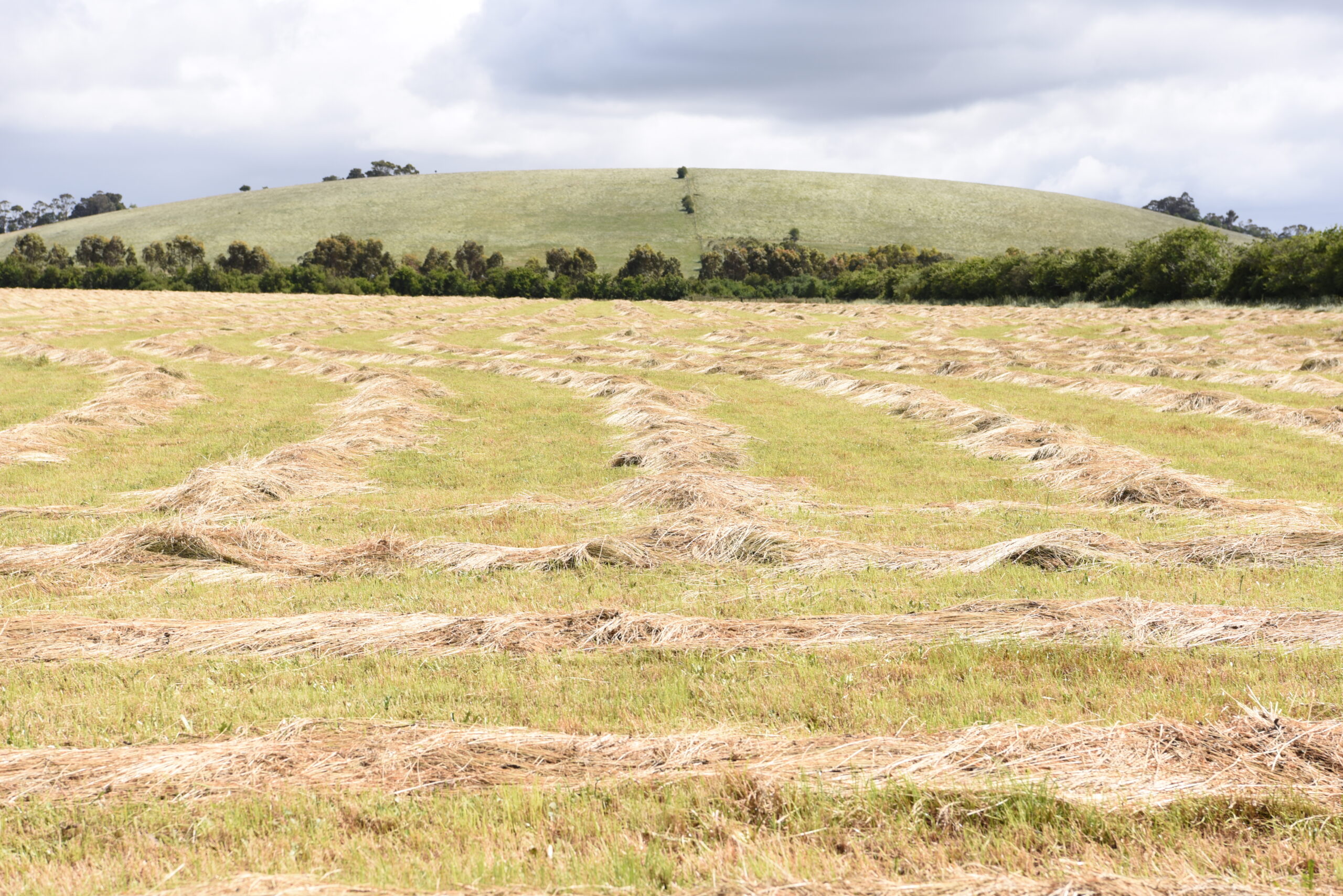
Mount Rowan
Mount Rowan is a significant landmark and represents the cultural history of the Wadawurrung people, integrating elements of intangible and tangible cultural heritage. Mount Rowan is labelled as ‘regional open space’ in the PSP and will be protected from development.
We have engaged the Wadawurrung Traditional Owners Aboriginal Corporation (WTOAC) to produce a Cultural Values Assessment (CVA), which identifies the cultural heritage values associated with the precinct.
WTOAC are the Registered Aboriginal Party for the lands which the Ballarat North Precinct is located on.
Ballarat North is part of an active cultural landscape, with connections to the Wadawurrung People and their creation stories. The PSP will protect Mount Rowan and ensure majority of Burrumbeet Creek remains in its naturalised state. The PSP will also prevent development in areas of high cultural sensitivity.
A Post-Contact Heritage Assessment was undertaken for the PSP, which recommended the Heritage Overlay to be applied to the following five sites to recognise their historical significance:
- Bernera Homestead, 88 Olliers Road, Mount Rowan
- Chalmers Homestead, 15 Sims Road, Mount Rowan
- Hawthorn Farm Homestead, 134 Gillies Road, Mount Rowan
- Hawthorn Park, 112 Olliers Road, Mount Rowan
- Scott Homestead, 103 Olliers Road, Mount Rowan
The precinct currently includes land that is subject to inundation in a 1% Annual Exceedance Probability (AEP) event, also known as a 1-in-100 year event.
We have undertaken extensive flood modelling to determine the impacts of 1% AEP flooding event. In consultation with the City of Ballarat and Glenelg Hopkins Catchment Management Authority (GHCMA), the PSP has been developed to ensure no increase in flooding offsite is created by the precinct and to ensure new homes in the precinct are also protected.
The PSP addresses stormwater and flooding impacts by:
- Not locating new residential use or schools in areas that have a high flood hazard.
- An urban standard drainage system, including requiring new retarding basins in strategic locations in the precinct.
- Enhancing and protecting the Burrumbeet Creek to provide additional flood protection.
- Encourage Water Sensitive Urban Design and Integrated Water Management strategies to enhance catchment resilience.
The VPA acknowledges the many challenges and opportunities of planning for a changing climate. We also appreciate the unique ecological landscape of the precinct and strive to understand and protect as much of it as possible.
Our plan includes guidelines to reduce the urban heat island effect by setting a target of 30% tree canopy cover in public spaces. This target will be supported by protecting valuable existing native trees and habitats within the open space network.
The PSP will encourage a shift to lower-emission travel to, from and through the precinct by providing bus-capable roads and an extensive network of cycling and walking trails.
Water Sensitive Urban Design and Integrated Water Management are central to the PSP and have been incorporated into the design of the new stormwater drainage network, streetscapes and open spaces. This includes opportunities such as rainwater tanks, passive irrigation and the potential use of recycled water.
Additional requirements and guidelines encourage the integration of alternative energy sources, as well as the inclusion of electric vehicle infrastructure and battery storage in the design of the precinct.
Accessible green space
The provision of multi-functional public open space will form a key objective of the precinct. The precinct boundary includes the Ballarat Town Common. The retention and potential upgrade of the Town Common as well as the development of new public open spaces will form part of the project to ensure all residents have accessible, high quality public open space in their neighbourhood.
Active transportation
The provision of active transport initiatives to reduce car dependency and support low carbon footprint, through encouraging a permeable street network, higher densities along main transport routes and co-locating key activities where transport routes intersect. Walking and cycle paths will provide additional access and ultimately connect adjoining residential communities into the Precinct.
Responses to environmental features and assets
The precinct intends to take advantage of natural features including Burrumbeet Creek, Mount Rowan and patches of remnant vegetation to provide for passive nature-based recreation, revegetation and enhancement of biodiversity features, whilst preserving key view lines.
Integrated outcomes
Integrate outcomes with adjoining Activity Centres, employment areas and surrounding communities where possible to provide community infrastructure which considers the surrounding areas.
Recognition and conservation of heritage places
Seek to conserve, protect and celebrate places of aboriginal and post contact heritage significance to ensure the history and character values of the precinct are reflected through the future development.