Merrimu Precinct Structure Plan
The Victorian Planning Authority (VPA) is working with Moorabool Shire Council to prepare a Precinct Structure Plan (PSP) and Development Contributions Plan (DCP). The precinct will deliver housing, community and education facilities, a retail centre with local employment opportunities, along with a series of local parks, roads and a drainage network to support the future community.
Public consultation is now closed
Public consultation on draft C109moor to the Moorabool Planning Scheme is now closed. We are now reviewing all submissions and will reach out to submitters as required.
If you have any questions, please contact us via Merrimu@transport.vic.gov.au.
For more information, refer to Merrimu Precinct Structure Plan | Engage Victoria.
Site context
The precinct is located northeast of Bacchus Marsh town centre approximately 46 km north-west of Melbourne and covers an area of approximately 907 hectares.
Lying on an elevated plateau, the area has a strong visual landscape with rolling hills and views that extend down to Bacchus Marsh. The plateau is relatively flat with extreme steepness around the escarpment where development is highly constrained. The escarpment area holds potential Aboriginal Cultural Heritage and biodiversity values and are impacted by sodic soil and erosion constraints.
The precinct currently comprises of agricultural land uses (with south and south-east boundaries of the PSP partly located within the Bacchus Marsh Irrigation District), nature reserves and established rural residential development. Long Forest Reserve defines Merrimu PSP’s eastern boundary and is a strong feature of the landscape in the area. To the western boundary are a range of operational and non-operational sand quarries.
The PSP area has been identified by the Department of Transport and Planning (DTP) to be transversed by the proposed Bacchus Marsh Eastern Link Road which is a future major arterial road development. Option B, which runs between Bences and Gisborne Road, has been selected as the preferred alignment. At the northern boundary, the Western Renewables Link is proposed to run through the precinct, which will carry renewable energy from Bulgana to Sydenham.
Map of the Merrimu Precinct Structure Plan – Plan 2 – Place Based Plan
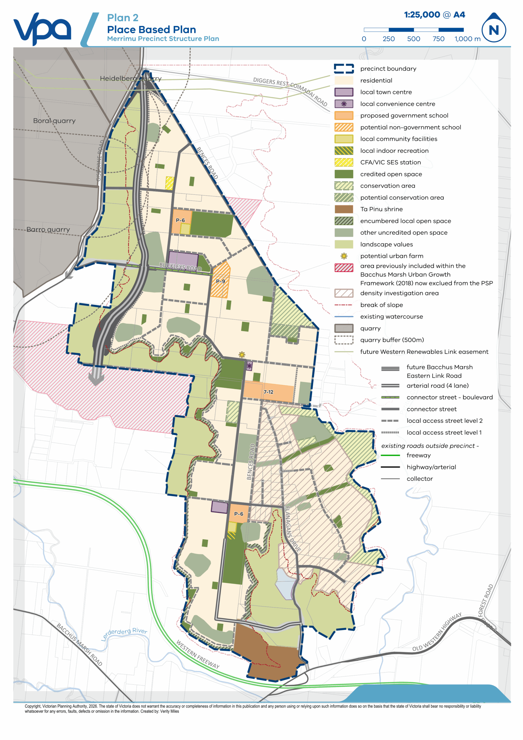
Map of the Merrimu Precinct Structure Plan – Plan 2 – Place Based Plan
About the project
The Victorian Planning Authority (VPA) is working with Moorabool Shire Council to prepare a precinct structure plan (PSP) and Development Contributions Plan (DCP). The precinct will deliver a mix of 8,000 new homes and 1,800 local jobs for an estimated 24,000 new residents. It will deliver education facilities, a retail centre and a series of local parks, roads and a drainage network to support the future community.
Bacchus Marsh has been identified for growth through a range of state, regional, and local policy. These include but are not limited to the Central Highlands Regional Growth Plan, Plan Melbourne 2017-2050, Housing Bacchus Marsh to 2041 and Bacchus Marsh Urban Growth Framework.
The Merrimu Precinct Structure Plan will be a major contribution towards the 20,000-household target for Moorabool Shire Council by 2050 under the Victorian Government’s Housing Statement.
To accommodate this growth, the project will assist in providing additional housing and supporting infrastructure for the community and region.
A planning scheme amendment involves either a change to a planning scheme map, a change to the written part of the scheme, or both.
Amendments to a planning scheme can have significant planning implications as they change the way land can be used or developed, which changes the basis of planning decisions in the future.
The VPA is facilitating a whole-of-government approach which includes consulting with all relevant stakeholders, including state government agencies, council, landowners, businesses, Traditional Owners and local residents.
For more detail on the planning process to date, including the extensive research and analysis that has been undertaken, refer to the Supporting Documentation section below.
A Development Contributions Plan (DCP) identifies the costs of some essential infrastructure required to support a PSP such as the costs of intersections, drainage corridors, retarding basins, and others. It will also set out a levy required for new development on a ‘per hectare of net developable area’ basis.
The DCP is required since broad scale new development often contribute to or cause the need for new or upgraded infrastructure. It ensures that existing infrastructure is not over-burdened by new development.
The DCP will be prepared concurrently with the PSP. All infrastructure items included must be strategically justified through a suite of background studies undertaken on the project. The DCP becomes a public document publicly exhibited along with the PSP.
Key themes from the previous engagement are:
- The status of the Eastern Link Road, and the need to maintain site access to properties in the future
- The impact of increased density on the character of the surrounding area
- The extent of conservation area within the precinct and the need for ongoing property access for future biodiversity assessments
For more detail on the planning process to date, refer t0 the Supporting Documentation below.
The Windfall Gains Tax applies to land value increases by more than $100,000 due to government rezoning. The Windfall Gains Tax will be applicable in most instances in the Merrimu Precinct.
The tax does not apply to some types of land, including residential land up to 2 hectares, land owned by charities and land rezoned to certain public or rural zones.
The tax is charged when the land is rezoned, not when the land is sold or developed. The person who owns the land when it is rezoned is responsible for paying the tax. You can defer paying the tax until the land changes hands or for 30 years.
For more information, contact the State Revenue Office.
Third party funding is the method adopted by the VPA to fund the preparation of a precinct structure plan (PSP) and development contributions plan (DCP). Funding facilitates the preparation of or updates to technical work, stakeholder consultation and associated work to prepare a planning scheme amendment to incorporate the PSP and DCP into the Planning Scheme.
Third Party Funding Agreements are a contract between the VPA and a third party (typically the landowner) to formalise funding arrangements. Typically, costs to fund a PSP is undertaken on a per hectare basis (i.e. the larger your landholding, the more it will cost.) The agreements provide for staged payments over the course of the PSP process.
The VPA has used Third Party Funding to fund the preparation of the Merrimu Precinct Structure Plan and Development Contributions Plan. Funding is voluntary and allows landowners to contribute to the cost of technical studies and planning, ensuring faster project progression.
Landowners with sites containing habitat (as identified by the DEECA habitat distribution model) which may support the Victorian Grassland Earless Dragon (VGED) have been notified by the VPA in December 2024.
To read more about the habitat distribution model, visit: Victorian Grassland Earless Dragon habitat distribution model.
Public Acquisition Overlays
A PAO reserves land for a public purpose and indicates that your land has been designated for compulsory acquisition. The PAO may also restrict the use and development of your land. PAOs are a legislated planning tool and – once approved via a Planning Scheme Amendment – will form part of the Moorabool Planning Scheme.
There is no expiry date for PAOs. They can be placed on land indefinitely, until that land is required for its intended purpose. In future, if it is determined that your land is no longer required for the intended purpose, the PAO will be removed.
The application of a PAO is considered best practice to ensure timely delivery of infrastructure needed to support the new community. It facilitates:
- Transport infrastructure such as road upgrades
- Drainage infrastructure such as outfall construction
Moorabool Shire Council and Melbourne Water are the Acquiring Authorities under the Planning and Environment Act 1987 to implement the public acquisition within the PSP.
The PAOs identified for the Merrimu Precinct will be for one of two land uses:
- The PAO will be applied to identified land to reserve it for a road upgrade and indicates that this land could be compulsorily acquired in the future. The acquiring authority for this land is Moorabool Shire Council.
- The PAO will be applied to identified land to reserve it for drainage outfall construction and indicates that this land could be compulsorily acquired in the future. The acquiring authority for this land is Melbourne Water.
To have a better understanding of what you can and cannot build upon land impacted by a PAO, speak directly with Moorabool Shire Council or Melbourne Water.
The VPA has engaged Wurundjeri Woi-wurrung Cultural Heritage Aboriginal Corporation (WWCHAC) to prepare a Cultural Values Assessment (CVA), and to consult in relation to an Aboriginal Cultural Heritage Impact Assessment being prepared by a heritage consultancy, to investigate Aboriginal cultural heritage and values associated with the precinct. These studies are not completed yet.
WWCHAC is the Registered Aboriginal Party for the lands on which the Merrimu precinct is located.
The VPA is working with WWCHAC, who will provide advice to progress with the planning in the most appropriate way to protect Aboriginal cultural heritage and values.
Transport and traffic
Road infrastructure will be upgraded in the future to accommodate growth.
Transport modelling is being undertaken as part of the planning process. This includes creating a traffic model to identify impacts, determine key road, intersection and freeway interchange upgrades, and connections to major arterials.
The Bacchus Marsh Urban Growth Framework identified an Eastern Link Road for Bacchus Marsh as a key project to address existing network and congestion issues, as well as to support the development of new growth areas.
Regional Roads Victoria (RRV) has nominated Option B Alternative as the preferred alignment for the Bachus Marsh Eastern Link Road. The Victorian Planning Authority (VPA) will continue collaborating with RRV to ensure that the Eastern Link Road effectively integrates and supports the development of the precinct.
For more information on the Bacchus Marsh Eastern Link Road, refer to Regional Roads Victoria.
Environment and biodiversity
The precinct is informed by detailed environmental assessments, including habitat mapping and analysis of protected species and ecosystems.
The precinct design will also include strategies for managing stormwater and protecting natural waterways.
Measures are put in place to avoid or offset impacts on biodiversity and sensitive areas as much as possible.
Project background
The Victorian Planning Authority is working with Moorabool Shire Council to actively engage with precinct stakeholders, including landowners, to prepare a precinct structure plan (PSP) and development contributions plan (DCP). The precinct is partly ‘proponent led,’ with Bacchus Marsh Developments Pty Ltd leading specific technical aspects while the Victorian Planning Authority has oversight of the total precinct.
The Victorian Planning Authority (VPA) is a State Government statutory authority within the Department of Transport and Planning that reports to the Minister for Planning.
The VPA is responsible for planning new suburbs and renewal sites in Victoria. The VPA is the designated Planning Authority, which means it is responsible for this amendment.
Bacchus Marsh Developments Pty Ltd/Stamoulis Property Group is the largest landowner within Merrimu precinct and owns the majority of the precinct. To facilitate the timely delivery of the precinct structure plan and to avoid duplication, the VPA is utilising various technical reports prepared by the landowner but subject to VPA quality assurance and oversight.
The VPA continues to provide project management, quality control, and probity oversight to the project in its role as the Planning Authority for the amendment.
Background information
The Victorian Planning Authority (VPA) is a State Government statutory authority within the Department of Transport and Planning that reports to the Minister for Planning.
The VPA’s main task is to make sure Melbourne and Victoria’s regions remain great places to live and work. This requires vision and long-term planning to ensure our growing population has equitable access to employment, public transport, attractive public spaces and affordable housing.
Our key priorities include unlocking land for new homes and communities, facilitating housing diversity and affordability, job creation and better development of new communities in growing and established areas.
We do this by working closely with councils, government agencies and the planning and development community on integrated land use and infrastructure coordination for new communities and strategically important precincts.
The Minister for Planning has appointed the Victorian Planning Authority (VPA) to lead this project from conception to finalisation. Throughout the project, we will work closely with Moorabool Shire Council, State Government agencies and local community members to ensure the plan considers and reflects their input.
A Precinct Structure Plan (PSP) is a land use and infrastructure plan to guide the development of an area over time. It provides certainty for community members and developers by providing a long-term vision for how an area will develop in the future.
A PSP sets out the preferred locations of residential and employment land and infrastructure, and provides guidance for transport and parking, urban design, heritage and character, open spaces and integrated water management.
Together with the broader planning framework, precinct structure planning is an important part of the Victorian Government’s strategy to address population growth, housing and employment demands.
The Bacchus Marsh Urban Growth Framework (UGF) identifies new areas for jobs, housing and infrastructure, while protecting valuable cultural and environmental assets. With Bacchus Marsh’s population anticipated to more than double to 50,000 residents by 2041, this plan will ensure growth is logical, sequenced and holistic. The framework was approved by the Minister for Planning in November 2018.
The framework identifies Parwan and Merrimu as key growth areas. The precinct structure plan (PSP) process will deliver more specific land-use planning for these areas to develop.
A Development Contributions Plan (DCP) identifies the costs of some essential infrastructure required to support a PSP such as the costs of intersections, drainage corridors, retarding basins, and others. It will also set out a levy required for new development on a ‘per hectare of net developable area’ basis.
The DCP is required since broad scale new development often contribute to or cause the need for new or upgraded infrastructure. It ensures that existing infrastructure is not over-burdened by new development.
The DCP will be prepared concurrently with the PSP. All infrastructure items included must be strategically justified through a suite of background studies undertaken on the project. The DCP becomes a public document to be publicly exhibited along with the PSP.
To implement the PSP and DCP, a planning scheme amendment to the Moorabool Shire Council Planning Scheme must first occur.
A planning scheme governs the way land can be used and developed within the bounds of the Victorian Planning System.
A planning scheme amendment is updated from time to time to change the way land can be used or developed or to improve a particular scheme.
Bacchus Marsh Developments Pty Ltd / Stamoulis Property Group is the largest landowner within Merrimu precinct and owns the majority of the precinct. To facilitate the timely delivery of the Precinct Structure Plan and to avoid duplication – the VPA is utilising various technical reports prepared by the landowner but subject to VPA quality assurance and oversight.
The VPA continues to provide project management, quality control, and probity oversight to the project in its role as the Planning Authority for the amendment.
The VPA is working with Bacchus Marsh Developments Pty Ltd / Stamoulis Property Group to finalise the regular suite of technical reports. In addition to this work, the VPA has also commissioned its own site specific technical work – including but not limited to:
- The appointment of Tract to produce a Residential Capacity Testing report focusing on four key areas within the Merrimu Precinct: O’Connell Road Slope, Wells Court existing developed area, Flanagan’s Drive existing developed area, and Possum tail Run existing developed area. The Residential Capacity Testing Report will ultimately provide recommendations on:
- Appropriateness of each area for further subdivision.
- Appropriate dwelling density (per NDA hectare) including any lot size specifics required to inform PSP or ordinance.
- Appropriate controls to mitigate the visual impact of development in this area such as management of earthworks, building type / size, and revegetation screening.
- Planning controls to guide subdivision and development proposals in these areas.
- The appointment of SMEC to produce Preliminary Road Alignment Feasibility Advice (including preliminary design and costing) relating to three potential road projects within the precinct area:
- RD-01 – Buckleys Road between Gisborne Road and the western extent of the Bacchus Marsh Eastern Link Road
- RD-02 – Flanagans Drive between Bacchus Marsh Road and Lindsay Avenue
- RD-03 – A new East-West Connector Road from the southern extent of Bences Road to the southern extent of Flanagan’s Drive.
Once complete – the results of both of these studies will be published on the VPA website.
Project information
Once approved, development within the precinct will gradually occur over the next few decades.
Council is the responsible authority for the PSP and will be responsible for the planning application process that will deliver outcomes as outlined in the PSP and DCP.
Developers are responsible for preparing and lodging planning applications that must be generally in accordance with outcomes of the PSP and DCP.
The Bacchus Marsh Urban Growth Framework identified an Eastern Link Road for Bacchus Marsh as a key project to address existing network and congestion issues, as well as to support the development of new growth areas.
Regional Roads Victoria (RRV) have nominated Option B Alternative, as the preferred alignment for the Bacchus Marsh Eastern Link Road. The Victorian Planning Authority (VPA) will continue collaborating with RRV to ensure that the Eastern Link Road effectively integrates and supports the development of the precinct.
For more information on the Bacchus Marsh Eastern Link Road, refer to Regional Roads Victoria.
General information about the Victorian Grassland Earless Dragon (VGED) can be found at the Zoos Victoria website.
Additionally, for specific inquiries and details on potential VGED populations and surveys, the Victorian Planning Authority (VPA) is collaborating with the Department of Energy, Environment and Climate Action (DEECA).
You can contact DEECA for further information via:
- Email – customer.service@delwp.vic.gov.au
- Telephone – 136 186
Bacchus Marsh has been identified for growth through a range of state, regional, and local policy. These include but are not limited to the Central Highlands Regional Growth Plan, Plan for Victoria, Housing Bacchus Marsh to 2041 and Bacchus Marsh Urban Growth Framework.
Plan for Victoria facilitates growth in order to support regional communities. The Plan identifies Parwan Employment Precinct as a regional employment precinct. The precinct’s scale, regional and capacity to deliver industrial land will help promote economic competitiveness and resilient regional growth.
The Economic Growth Statement also demonstrates a commitment to support businesses to invest and grow Victoria’s priority sectors including circular economy, digital technologies and agribusiness within the next 10 years. The Statement recognises unlocking land for jobs in regional greenfield locations as a conduit of statewide economic growth. The preparation of the Parwan Employment Precinct is aligned to this Statement by unlocking approximately 2,200 hectares of new industrial land adjacent to the fast-growing Bacchus Marsh township. New investment into the region will transform Moorabool Shire into a significant regional employment centre.
Victoria’s 10-year Plan for Industrial Land addresses the growing demand for well-located and affordable industrial land, particularly in greenfield sites. The Parwan Employment Precinct is well placed to contribute to the supply of attractive industrial sites, ready to support an evolving industrial landscape. As a regional precinct, Parwan Employment Precinct will alleviate pressure off metropolitan areas and provide more confidence for businesses to grow.
Landowners with sites containing habitat (as identified by the DEECA habitat distribution model) which may support the Victorian Grassland Earless Dragon (VGED), have been notified by VPA in December 2024.
To read more about the habitat distribution model, head to: Victorian Grassland Earless Dragon habitat distribution model.
Having your say
Any person, including residents, landowners and other affected community members, can make a written submission on draft Amendment C109moor and accompanying documents.
The draft Amendment and supporting documents are publicly available free of charge on the VPA’s project webpage and on the Engage Victoria webpage under the Documents section.
Contact the team if you would like to receive translated copies of any material via Merrimu@transport.vic.gov.au
Submissions must be received by Monday 30 March 2026 at 5pm.
Submissions received after this date may not be considered by the VPA and will be assessed to determine how or if they can be considered.
Submissions on Amendment C109moor must be made in writing to the VPA via the submissions form on this page or by post.
Post: Victorian Planning Authority
c/- Merrimu Precinct Structure Plan
GPO Box 2392
Melbourne VIC 3001
We have prepared a How to Make a Submission guide to help you navigate making a submission on a planning scheme amendment. You can access it on the Documents section on the Engage Victoria webpage or on the VPA webpage.
Submissions provided to the VPA are part of an open public process where all parties affected by the planning scheme can provide input into the draft amendment.
If you choose to make a submission, you consent to your submission being made public, and being identified as the author of the submission.
Your submission will be made available for public inspection on the VPA website until two months after gazettal of the resulting planning scheme amendment and will also be made available to relevant Ministers and local councils, and other involved government agencies.
If you are a private individual, your personal information will be removed from your submission before it is released to parties outside government or local councils. Contact details do not include the address of land which is the subject of your submission.
By making a submission, you also give permission for copyright material to be copied and made public.
You can contact the VPA project team Monday to Friday 9am – 5pm via:
- Mat Garner (Director – Metro Melbourne) on 03 9651 9619
You can also email the team via Merrimu@transport..vic.gov.au
Next steps
Once a submission is made to the VPA, you will receive a notice to acknowledge it has been received.
After the consultation period ends, VPA staff will review all submissions received. As part of this process, VPA staff may contact submitters as required to further discuss their submission and any changes sought.
If required, draft Amendment C109moor may be subject to the VPA Projects Standing Advisory Committee (SAC). The SAC has been established to provide independent advice on draft planning scheme amendments to the VPA and the Minister for Planning.
While the VPA will seek to resolve issues raised by submitters, following the public consultation process, the Minister for Planning will be advised of the outcomes and provided with options to resolve submissions, including, but not limited to, referral to the SAC. If so, submitters will be contacted regarding next steps, process, and timing.
You can stay up to date by subscribing to the project newsletter in the ‘Subscribe now’ fields on the right-hand toolbar of this webpage and if you are a developer, landowner or Agency partner please complete the form found at the above tab titled “Stakeholders”.